Ancestors of Isaac T. Lafaver 1801
by Jeffrey La Favre
jlafavre@gmail.com
2. Johannes (John) Lefever abt. 1702-1779
3. Abraham Lefever
[Abraham Lefever (I)]
b: 1728 in New Bristol, Philadelphia County, Pennsylvania - this date
needs verification
d: Aft. 21 JUN 1796
Elizabeth (wife)
b: Unknown
m: 1748 - this date needs verification
d: Aft. 21 JUN 1796
Children of Abraham Lefever (I) and Elizabeth
Abraham Lefever (II)
b: abt 1750Catherine (wife)
Christina
b: 16 MAR 1751 Northampton Co., PA - CONGREGATION OF THE AUGSBURG CONFESSION IN SAUCON AT PHILIP SCHLAUGH'S, NOT FAR FROM THE BIG LEHIGH AND FORKS OF THE DELAWARE, Church Book, p. 11: Christina Feber, daughter of Abraham and wife Elisabeth, bapt. 21 MAR 1751, sponsors Georg Kiefer and Margaretha MohrBalthasar Lefever
b. 8 MAY 1757, bapt. 12 JUN 1757, sponsors at baptism Melchior Hey and Susanna 6Susanna Lefever - needs verification
b: abt 1758Catharina
m. Casper Zilling April 8, 1766, Market Square Presbyterian Church, Germantown, Philadelphia, PA
We find the following tax information in Worcester twp., Phil. Co, PA for Casper.1767 Caspar Zealing, 2 horses, 3 cows, tax 2.6.8
1769 not listed in Worcester
1774 Caspar Zilling, 1 horse, 2 cattle, tax 1.6.8
1779, 80, 81, 82 not listed in WorcesterThere was a Casper Silling who purchased land from William Anderson and Rebecca and Samuel Anderson, 20 MAR 1776 (Augusta Co. Deed Bk 21, p. 545). The land was part of 195 acres patented to Robert Boyd, 10 MAR 1756, and conveyed to Robert Boyd, heir of Robert, to Robert Young. Casper Silling of Augusta Co. may be the same man as Casper Zilling of Philadelphia Co.
Listed below are three children of Casper and Catharina based on baptism records of Wentz Church, Worcester twp., Philadelphia Co., PA
Abraham b. 15 FEB 1767, Worcester Twp., Philadelphia Co., PA
Eva Barbara b. 15 FEB 1773, Worcester Twp., Philadelphia Co., PA
George b. 5 FEB 1775, baptized 11 JUN 1775, Worcester Twp., Philadelphia Co., PA
Abraham served on the Northampton County Grand Jury in June of 17591 and was a witness to the baptism of his sister's child, Abraham Van Etten, on May 2, 1760.6 The baptism was most likely performed in Northampton County.
Abraham moved to Norriton Township, Philadelphia County, Pennsylvania, where he purchased 200 acres on January 15, 1761.56 On October 22, 1766, he and his wife, Elizabeth, sold half of the tract to John Martin Abish.1, 56 The following is the description in the deed of the land sold: Beginning at a corner of Mathias Rittenhouses land thence by the same North 49 degrees 30 minutes West 62 perches to a stone thence by the other land of Abraham Lefevre the five following courses, North 22 degrees 45 minutes East 127 1/2 perches, to a stone, North 47 degrees 45 minutes West 5 1/2 perches to a stone, North 46 degrees 30 minutes East 30 perches to a stone, South 47 degrees 45 minutes East 18 perches to a stone, North 42 degrees 15 minutes East 35 perches and thence by the same South 46 degrees 20 minutes East 88 perches 3 feet to a stone in the line of Robert Shannons land thence by the same and lands of Jacob Slough and the late James Shannon South 42 degrees 15 minutes West 181 1/2 perches to the place of beginning - 100 acres 90 perches.
Abraham's land in Norriton Township was mentioned in a deed of a neighbor, Matthias Rittenhouse, who sold 72 acres and 148 perches to his son, David, on January 12, 1770.2 The description of this tract allows us to locate Abraham's land. The Old Norriton Presbyterian Church, erected in 1698, still stands today (see this web page). This church is said to be located on a corner (the north west corner) of the Rittenhouse land (see this web page). Here is the description of David's land in the deed: "Beginning at a large Black Oak tree marked for a Corner. Thence, by Land of Doctor Robert Shannon North forty two degrees and an half East ninety seven Perches to a Stone. Thence by land of Christian Recup and Abraham Lefever North fifty degrees West, one hundred and thirty four Perches to a Stone. Thence, by other part of the said Matthias Rittenhouses Land South forty two degrees and an half West ninety five Perches to a Stone in a line of Ephraim Armstrongs Land and at the Manhatawney Road. Thence, down the said Road South Sixty two degrees East ninety two perches to a Stone. Thence by other part of the said Matthias Rittenhouses Land, South thirty two degrees West, Twenty Six Perches to a large Whiteoak in a line of the afforesaid Ephraim Armstrongs Land. Thence by the same South fifty degrees East thirty nine perches to the place of beginning."
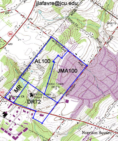
The Manhatawney Road became the Philadelphia, Germantown and Perkiomen Turnpike Road sometime between 1801 and 1804. If we plot the Matthias and David Rittenhouse tracts on a modern topographic map,with the north west corner of Matthias' tract at the intersection of Germantown Pike and Trooper Road, the border of the tracts aligns well with Germantown Pike. Then it is an easy matter to plot Abraham's land adjacent to David's. A large scale map is provided HERE. This map includes most of Worcester Township as well because this area was important to the Lefever family history. If we plot a route by modern roads, it is apparent that Abraham had to travel four miles from his home to worship at Wentz's Church on Skippack Pike in Worcester.
While we don't have the description of Abraham's original 200 acres, the deed of sale for half the land in 1766, coupled with the description of David Rittenhouse's land, allows us to reconstruct an estimated description as follows: Beginning at a corner of Mathias Rittenhouses land thence by the same North 49 degrees 30 minutes West 172 perches, then North 42 degrees 15 minutes East 190 perches, then South 46 degrees 20 minutes East 172 perches, then South 42 degrees 15 minutes West 181 1/2 perches to the beginning.
A plot of the tracts in Norriton is provided below (MR = Matthias Rittenhouse, DR72 = David Rittenhouse, JMA100 = John Martin Abish, AL 100 = Abraham Lefever [I])
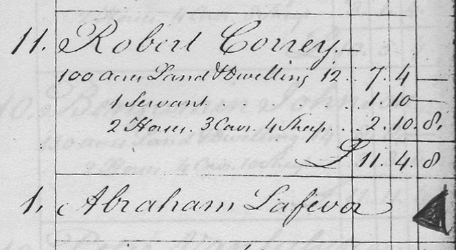
Abraham is on the tax list for Philadelphia County, in Norriton Township, for the year 1767. He was taxed for 100 acres with dwelling, 2 horses, 5 cows, 10 sheep and 1 servant (on October 4, 1764, Abraham purchased the servitude of Ludowick Rainbold [Ludwig Reinbold] for a term of 2 1/2 years. ). In 1769, in Norriton, Abraham was taxed for 100 acres with dwelling, 1 horse/cow, 6 sheep and 1 servant . The deed of sale for Abraham's remaining 100 acres in Norriton Township is not listed in the index of deeds for Philadelphia County. Norriton was included in a new county, Montgomery, on September 10, 1784. Further searching in Montgomery County may shed light on the fate of Abraham's last 100 acres in Norriton. However, it appears that Abraham did not own land in Norriton at the time of the 1774 tax assessment, because he is listed without any property.
(image below page 353, Philadelphia County tax assessment for Norriton Twp., 1774 - triangular arrow to right of Abraham Lafevor's name applied to photocopy as a place marker)
As mentioned above, Abraham's land in Norriton was four miles from Wentz's Church, where we find the family in the church records. Abraham and Elizabeth were sponsors at Wentz's Church (present day Worcester Township, Montgomery County, PA) at the baptisms of five children:57
Elisabetha, daughter of Jacob and Margretha Senger, b. 14 SEP 1766, bapt. 28 DEC 1766
Abraham, son of Casper and Catharina Zilling, b. 15 FEB 1767, bapt. 22 MAR 1767 - Abraham and Elizabeth Lefeber, grandparents
Elisabetha, daughter of Andrea and Anna Barbara Jaeger, b. 26 FEB 1768, bapt. 23 MAY 1768
Abraham, son of Johann Henrich and Anna Maria Scheib, b. 3 DEC 1768, bapt. 15 MAY 1769
Adam, son of Philip and Anna Maria Vetter, b. 20 OCT 1769, bapt. 13 MAY 1770
In addition, there are two other children of Casper and Catharina Zilling in the records:
Eva Barbara, daughter of Casper and Catharina Zuelling b. 15 FEB 1773, bapt. 8 AUG 1773, sponsors Michael Zilling and wife
George, son of Casper and Catharina Zilling b. 5 FEB 1775, bapt. 11 JUN 1775, sponsors George Zilling and Elizabeth Horrman, both single
The relationships of the mothers to Abraham and Elizabeth are clear only for Catharina Lefeber Zilling. Two of the women apparently were not daughters of Abraham and Elizabeth. Anna Maria Fissler married Philip Fetter. Margaret Bock married Jacob Saenger on February 11, 1766. The remaining two women, Margretha (Senger) and Anna Maria (Scheib) may or may not have been daughters of Abraham and Eizabeth. If the pastor at Wentz's Church always recorded any blood relations of the sponsors, then the latter two women would not be daughters. We are left to wonder if that is the case.
The first two children of Abraham's son, Abraham Lefever (II), are said to have been born in Pennsylvania in 1772 (Abraham III) and 1774 (Andrew). It seems likely that Abraham (II) would also attend the church of his father if he lived near or with him in Norriton. If this was the case, then why don't we find records for the baptisms of Abraham (III) and Andrew? There is an Abraham Lafavor, innholder, on the 1769 tax list in the Mulberry Ward of the city of Philadelphia. He is also on a 1771 list of public housekeepers, located on Second St., Philadelphia.78 Is this the son of Abraham Lefever (I)? Further investigation is needed.
Augusta and Washington Counties, Virginia
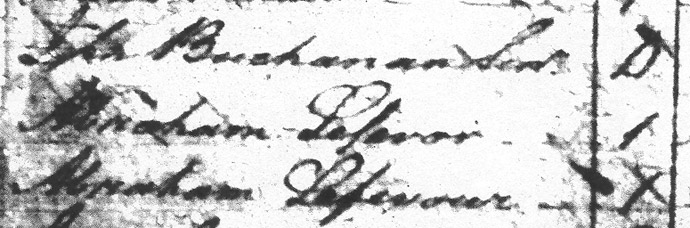
The details of Abraham's migration movements are not certain. Sometime between 1770 and 1777 it appears that he and his son, Abraham (II), left Pennsylvania and moved to Virginia. There is documentation that Abraham Lefever (I) lived in Washington and Augusta Counties. Either of these counties could have been his first place of residence. In the Augusta court records16, on 20 AUG 1777, there are instructions to create tithables lists for various companies, including Capt. Patrick Buchanan's. I believe the tithables lists contained the names of all taxable persons within each militia district, identified by the name of the captain in charge of the company. If this was the case, then the list of names was not the captain's roster, but all taxable individuals in his neighborhood. On a 1777 Tithables list for Capt. Buchanan's company15, there are two Abraham Lefevers. I believe the exact spelling of the surnames are as follows: Abraham Lefevor and Abraham Lefevour, but you may judge yourself using the image below. The number of tithables for each Abraham is listed as one and in the land column no number is present (i.e., they did not own land in Augusta Co.). Note that the person listed just before the Lefevers was John Buchannan Sen. Our confidence that the two Lefevers were related might be stronger if they were indicated as senior and junior, but the designation does not guarantee a relation, only that one was older than the other. Furthermore, we should not rule out a relation between the two Abrahams due to a minor variation in the spelling of their surnames.
Could the men on this tithables list be Abraham Lefever (I) and Abraham Lefever (II)? Abraham (I) would have been 48 or 49 years old at the time the Tithables list was created if he was born in 1728. Waddell reports in his book that the age range for militia duty was 16 to 50 years old10. Only one Abraham Lafavour is listed under the command of Capt. Buchanan in a list of Virginians in the Revolution.5 Since Abraham (I) was near the upper age limit for duty, I would presume that it was Abraham (II) who served in the militia. An Abraham Lefever was certainly in Captain Buchanan's company because the captain listed him as a delinquent due to his absence at one Private muster 25 OCT 1777. Abraham was fined 5 shillings for failing to come to the muster17.
(the image below was derived from Augusta County 1777 Tithables, Library of Virginia, Augusta Co. microfilm reel #110 - in a previous image there appeared to be "Jr." applied after the name of the second Abraham, but this must have been penciled in by a researcher)
The date of arrival of the Lefevers in Washington County is tied to a tract of 171 acres of land on the north side of the Middle Fork of Holston River, immediately west of present-day Chilhowie. However, documents examined to date do not clearly establish when the Lefevers came into possession of the land. The surveyor's record18 contains a survey for the 171 acre tract done for Abraham on February 24, 1785. At the bottom of the entry of this survey, the details of a Commissioners' Certificate are copied as follows: "We the Commissioners for the district of Washington and Montgomery Counties do certify that Abraham Lefever assignee of Josep Bullen who was assignee of George Hine who was assignee of Aaron Horn is entitled to 400 acres of land in Washington County joining Captain James Thompson on Holsten 261 acres of which was surveyed the 8th day of June in the year of our Lord 1774 ... to include his improvement he having proved to the court that he was entitled to the same by actual settlement made in 1774." The certificate was signed by the commissioners on April 18, 1781. Abraham received a grant from the State of Virginia for this land on May 2, 1787.
The certificate seems to indicate that Abraham settled the land in 1774. Then there is the confusing statement that 261 acres was surveyed on June 8, 1774. In order to clear the confusion, it is necessary to examine the original survey of 261 acres19. At the time of the 1774 survey, the land in question was in Fincastle County (Washington County was formed in 1777) and we must look there for the survey. The survey of June 8, 1774 was done for Aaron Horn. Therefore, Mr. Horn was in possession of the land at that date. The certificate indicates that Horn sold the land to Hine who in turn sold the land to Bullen who in turn sold the land to Abraham. If we are to believe that Abraham settled this land in 1774, then all of the transactions from Horn to Abraham would need to have occurred in a period of 6 months. While possible, it seems more likely that someone other than Abraham was the person who settled the land, probably Aaron Horn. If so, Horn sold his right in settlement, which was eventually documented as a Commissioners' Certificate in Abraham's name. In any case, Abraham was in possession of the land no later than the date of the certificate, April 18, 1781. We can't be sure which Abraham (I or II) owned the 171 acre tract but it was Abraham (II) who sold it in 1795 because his wife, Catherine, also signed the deed.
An examination of the survey data, along with neighboring tracts, indicates that the 261 and 171 acre tracts shared land in common as can be seen in the plots provided below. Plotting of the surveys reveals that they are not accurate because they don't close. The 171 acre tract has greater errors and was left open in the plot below. The errors of the 261 tract were adjusted slightly to create a closed survey, using neighboring tracts as guidance in fitting the tract to the available space. In reality, the 171 acre tract was probably much larger than the acreage calculated by the surveyor. A large portion of the error may have resulted from the difficulty in accurately determining the long line on the south east side, part of which runs through steep terrain near the river. This area of the tract was undoubtedly heavily wooded as it still is today. It is clearly evident in the surveyor's own plot that this long line was simply shifted from the actual angle given in the survey so that a closed survey could be displayed in the book. Clearly the surveyor knew his survey was not accurate but we must not be too harsh in our judgment. His instruments were vastly inferior to modern day surveying instruments and his work load was very heavy.
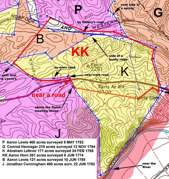
Abraham's 171 acre tract was bisected by the Great Road. We know this because the road is mentioned in his survey and in the survey of his neighbor, Conrod Hennegar. The survey data and topography of the area leave little doubt that the old road crossed Abraham's property in nearly the same path as US Highway 11, which is seen on the modern topographic map above. Interstate 81 runs next to Hwy. 11, but was removed from the map for clarity. The Great Road, also known as the Main Road, was an excellent location for a business that catered to travelers. Abraham surely selected this tract of land because he intended to operate a tavern along the road. In fact, there were several taverns in Abraham's neighborhood. This road was the main artery for white Americans moving to the surrounding frontier settlements and business must have been brisk.
On May 15, 1781, we find that Abraham Leafavour was in trouble with the county of Washington for serving alcohol to the public without a license. We can't be sure if Abraham (I) or (II) was charged with serving alcohol. Nevertheless, Abraham Lefeavour, Sr. appears on the personal property tax list for Washington County in 1782 and again for the last time in 1786. Also in 1782 and 1786 there is an Abraham Lefeavour, Jr. on the lists. Therefore, father and son were living in Washington County by 1782.
Given the evidence to this point, we might construct two scenarios of the Lefevers in Virginia. The first scenario would have them arriving as early as 1774 in Washington County. Then they moved to Augusta County where we find them on the 1777 Tithables list. After living in Augusta County for a short period of time, they returned to Washington County, where we find that one of the Abrahams obtained a Commissioners' Certificate on April 18, 1781. In order to believe this story, it would be helpful to find a motivation for Abraham to abandon his 171 acre tract in Washington County for a few years, spending some time in Augusta County.
During the Revolutionary War, agents for the British encouraged the Native Americans to attack white Americans on the frontier settlements. On July 20, 1776, the Virginia Militia fought Cherokees near the Long Island of the Holston River, about 55 miles south west of Abraham's property. On the same day, 400 to 500 settlers came together at Capt. Joseph Black's farm (present day Abingdon, VA) and started construction of Black's Fort, to be used as protection against Native American attacks. Abingdon is about 17 miles south west of Abraham's property. There were attacks on the settlers around Black's Fort in the summer of 1776. On James Thompson's land, Abraham's neighbor, a stone house, known as Kilmachronan, was constructed in 1776 to serve as a neighborhood fort. While many stayed on their land during the hostilities, perhaps the Lefevers felt their families would be safer in Augusta County.
The second scenario would have the Lefevers traveling from Pennsylvania to Augusta County sometime between 1770 and 1777. They would have lived there a few years, but did not purchase any land. Perhaps this county was only a temporary residence in their plans, with the goal of going soon to Washington County. They may have been discouraged from proceeding to Washington County for a time by stories of the hostilities in the area. Then sometime near the end of 1777 or not long after that, the Lefevers moved on to Washington County.
Three years after issue of the Commissioners' Certificate for the 171 acre tract, Abraham Lefever, Sr. (I) started the process of securing a second tract of land in Washington County20. In the surveyor's entry book we find the following entry with a date of March 16, 1784. Abraham Lefever assee of John Barr by state warrant No. 10941 enters 200 acres of land in Washington County lying on the waters of the south fork of Holston River beginning on the south west line of John Bakers old survey and bounded on the east by Joseph Cole and on the south by John Boles including the sugar camp and extending to Jam. Kithcarts [or Samuel Kithcart] for quantity and including Abraham Caseys improvement.
The survey for the 200 acre tract was done on May 5, 178421. This tract was located about 2 miles south east of the 171 acre tract. The neighbors mentioned in the survey were Adam Mourow [Morrow}, John Bowles and Robert Reagh [later granted to Nathaniel McClure]. Abraham obtained a grant for the tract from the state of Virginia on December 2, 1784.
The ownership history of the 200 acre Washington County tract is invaluable in tracing the Lefever family history over the years following the purchase by Abraham. As mentioned previously, Abraham Sr. (I) was listed for the last time in 1786 on the Washington County Personal Property Tax list. For some unknown reason, Abraham Sr. (I) decided to move to Augusta County, VA, leaving his son behind in Washington County. In Augusta County he purchased 280 acres from Phillip Barrick on February 18, 178822. On July 9, 1789, Abraham Lefever (I) appointed his son, Abraham Lefever, Jr., to be power of attorney to convey land owned by Abraham Sr. in Washington County [the 200 acres] to the same Phillip Barrick23. Two years after Abraham Sr. gave power of attorney to his son, Abraham Jr. (II) sold the land to Phillip Barrick on November 15, 179124.
While Abraham Sr. was living in Augusta County, he sold some land in North Carolina, which documents a connection to his father, John, back in Pennsylvania.
-------------------------------------------
Lincoln Co., NC Deed Book 4, p. 89
April 6, 1769. Boston Cline of Mecklenburg County to John Leufever of Berks County, PA of same, 350 acres where John Leufever now lives at branches of Lyles Creek in Lincoln County, granted to Boston Cline April 28, 1768...lease has Jacob Cline signing, release has Boston Cline "wrote in Dutch", Margaret Cline (x). Witness: Matthia Barringer with a Dutch name. (Mecklenburg Co. was formed in 1762 from part of Anson Co., Lincoln Co. was formed from a former part of Mecklenburg Co. in 1779)
--------------------------------------------
November 11, 1789, Abraham Lefever & wife Elizabeth of Augusta Co., Va to John Cressimore of Lincoln Co, NC: for 50 pounds sold 350 ac; was sold April 6, 1769 by Sebastian Cline (then of Mecklenburg & now of Lincoln CO, NC) to John Lefever (late of Berks CO, Pa), father of Abraham Lefever; John Lefever's will dated Oct. 28, 1778 (registered in Berks CO, Pa) divided his land in Pennsylvania but failed to do anything about above tract; Abraham Lefever is eldest son and is declaired heir-at-law. Signed Abraham & Elizabeth Lefever's marks. Witness John Jarrett, Michael Garber, & Henry Mowrey (or Monrey). Rec. Jul. 1790. Book 4 p. 89; Book 15 p. 342 Lincoln CO, NC Deeds New Book 4 & Old Book 15.
----------------------------------------
Less than a decade later, on June 21, 1796, we learn that Abraham Sr. and his wife Elizabeth sell their tract of 280 acres in Augusta County to Samuel Huff25. Apparently, a will for Abraham Sr. has never been found in Augusta County. The fate of Abraham Sr. and Elizabeth, after the land sale in 1796, remains a mystery. No documentation of their death in Augusta County has been found. No documentation has been found in Augusta County for any of Abraham's children other than Abraham Jr. (II). That is, unless we accept the possibility that Abraham's son-in-law, Caper Zilling, lived in Augusta County. Did the elderly couple spend their last years with the Zillings? Or did Abraham and Elizabeth have other children living in Augusta County? Further research may shed some light on the mystery.
CLICK HERE for a detailed map of land owned by Abraham in Augusta Co., VA
4. Abraham Lefever (II) abt. 1750-1807/8
last updated December 17, 2010
jlafavre@gmail.com