
This work by Jeffrey La Favre is licensed under a Creative Commons Attribution-Noncommercial-Share Alike 3.0 United States License.
This tract map is a work in progress. The latest edition is dated December 20, 2009.
Jeffrey La Favre jlafavre@gmail.com
See legend below map for tract details.
This work
by Jeffrey
La Favre is licensed under a Creative
Commons Attribution-Noncommercial-Share Alike 3.0 United States License.
|
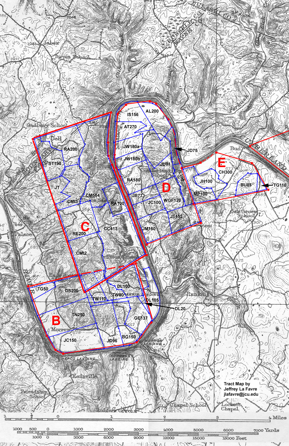
The background topographic map is USGS 15 minute quadrangle, Monticello, KY, published in 1911. It is the earliest map of the area available in the USGS series. The bottom lands near the river are now under water, due to construction of Wolf Creek Dam circa 1950. Tracts outlined in red are military surveys, done for veterans of the Revolutionary War, Virginia State Line. During the early 19th century these military surveys were subdivided into smaller tracts. These smaller tracts are outlined in blue. Military Survey B - Old Kentucky Patent Series - surveyed for Thomas Matthews - survey #4440 5 AUG 1791 - granted to Thomas Carneal - 1,348 acres. Careful examination of the subsequent subdivisions of this tract, and adjacent Military Survey C, reveal that the military surveys overlapped. While I have not researched this problem in detail, it appears that subsequent property owners of subdivisions of Survey C prevailed. Thus, I have applied a dashed red line to the boundary of Survey B that intrudes into Survey C. It is also evident that some of the subdivisions of Survey B intruded into Survey C, and these have dashed blue lines. Survey B was initially divided into 3 portions and purchased by James Daugherty, John L. Dibrell and Reuben Shores. These individuals made further subdivisions and sold to the individuals listed below for this survey (there are a few intermediary deeds that I have not included here - see the tract history page). Military Survey C
- Virginia Patent Series - surveyed for Elias Edmond - survey #6732 28
DEC 1787 - granted to Carter H. Harrison - 2,000 acres. The heirs of Carter
H. Harrison sold this tract to Anthony Gholson 30 AUG 1810 (Wayne County
Deed Book A page 291). Military Survey D - Old Kentucky Patent Series - surveyed for Thomas Matthews - survey #4439 6 AUG 1791 - granted to Thomas Carneal - purchased by Edmund Singleton - 1,521 acres. Most of this survey was subdivided and sold between 1813 and 1815. However, an internal portion and the south east corner remained in the hands of the heirs of Edmund Singleton until 1852, when they sold out to Solomon Turpin (Wayne County Deed Book L, pages 513, 566 and 567). Military Survey E
- Old Kentucky Patent Series - surveyed for Thomas Matthews - survey #4443
6 AUG 1791 - granted to Thomas Carneal - 460 acres The blue-bounded tracts are labeled with the initials of the owner and the number of acres. The labels are listed below. Included on the line with the label is the full name of the owner, followed by the deed reference and the date of the deed. For example, AL200 - Abraham Lefever (III) B:100 (6 MAR 1813) is a 200 acre tract owned by Abraham Lefever (III). Abraham's deed is recorded in the Wayne County, Kentucky, Deed Book B, starting on page 100. The deed is dated March 6, 1813. For further details about the tracts listed below, see the tract history page.
Subdivision of military survey labeled D AL200 - Abraham Lefever (III) B:100 (6 MAR 1813) - purchased from Edmund Singleton AT270 - Aaron Turpin B:303 (18 NOV 1815) - purchased from John Hawkins, executor of the estate of Edmund Singleton IS156 - Isaac Sinclair B:313 (18 NOV 1815) - purchased from John Hawkins JB77 - Joel Bond B:312 (18 NOV 1815) (77 1/2 acres) - purchased from John Hawkins JC100 - James Crooks B:300 (18 NOV 1815) - purchased from John Hawkins JD75 - James Daugherty N:91 (8 AUG 1855) - purchased from Solomon Turpin JL100 - Jacob Lefever B:282 (18 NOV 1815) - purchased from John Hawkins JT152 - Joseph Taylor N:82 (6 JAN 1855) - purchased from Solomon Turpin JM160 - James McHenry B:99 (6 MAR 1813) - purchased from Edmund Singleton JU81 - John W. Upton N:89 (10 AUG 1855) - purchased from Solomon Turpin JW180 - James White B:311 (18 NOV 1815) - purchased from John Hawkins
RA180 - Reuben Ard B:308 (18 NOV 1815) - purchased from John Hawkins WGF120 - William and Granville Foster N:88 (1 DEC 1855) - purchased from Solomon Turpin
Subdivision of military survey labeled B BG150 - Benjamin Gholson B:134 (7 JAN 1814) - purchased from James Daugherty et al. DL20 (20 1/2 acres) - David Lefevers B:491 (28 OCT 1818) - purchased from Thomas Wilson DL100 - David Lefevers D:287 (24 OCT 1826) - purchased from John L. Dibrell DL105 - David Lefever granted by Kentucky 4 JAN 1811, Grants South of Green River - this tract not part of military survey, but adjacent to the military survey DS200 - David Shores B:121 (12 APR 1813) - purchased from Reuben Shores GE137 - George Eller B:386 (27 FEB 1817) - purchased from Thomas Wilson JC150 - John Crooks C:48 (7 OCT 1818) - purchased from Reuben Shores JD96 - John Daugherty B:132 (5 JAN 1814) - purchased from James Daugherty TG50 - Thomas Gann B:122 (12 APR 1813) - purchased from Reuben Shores TN250 - Thomas Norman B:106 (13 APR 1813) - purchased from Reuben Shores TW80 - Thomas Wilson D:237 (25 APR 1826) - purchased from John L. Dibrell TW110 - Thomas Wilson D:237 (25 APR 1826) - purchased from John L. Dibrell
Subdivision of military survey labeled C CC413 -
Charles Conley L:107 (22 APR 1850) CMt2 -
Charles Mullins, Amy his wife, and Polly McGhee (the late Polly Heaven)
E:175 (13 APR 1830) CMt3 - Charles Mullins, Amy his wife, and Polly McGhee (the late Polly Heaven) E:175 (13 APR 1830) (see CMt2) CM564 - Charles
Mullins, Amy his wife, and Polly McGhee (the late Polly Heaven) E:175
(13 APR 1830) RA200 - Reuben Ard B:200 (24 JAN 1815) - purchased from James Dougherty RE200 - Robert Easley B:61 (20 OCT 1812) - purchased from Benjamin Gholson ST190 - Solomon Turpin B:428 (4 AUG 1817) - purchased from Benjamin Gholson RA100 - Reuben Ard D:408 (OCT 1827) - purchased from Benjamin Gholson. Reuben sold to Enos Cook L:77 26 MAR 1840 Subdivision of military survey labeled E BU85 - Benjamin Upton D:315 (4 APR 1827) - purchased from Thomas Gipson CH300 - Charles Hart D:215 (20 DEC 1825) - purchased from John L. Dibrell JH100 - John Hudgeons D:182 (29 AUG 1825) - purchased from John L. Dibrell MP100 - Micajah Philips C:50 (6 APR 1819) - purchased from John L. Dibrell TG110 - Thomas Gipson C:236 (27 APR 1821) - purchased from John L. Dibrell (Thomas sold 85 acres of his tract to Benjamin Upton [BU85]) Additional Tracts outside the military surveys Reuben Ard 150 acres surveyed 23 MAY 1811 (south of Green River series, survey #10496), granted 19 FEB 1833. A corner of this tract was on a line of military survey D, probably near the south east corner of the military survey. I am currently working to place this survey on the tract map. This tract was Reuben Ard's first land in Wayne County. James McHenry (Reuben Ard's half brother) 322 acres surveyed 10 DEC 1805, south of Green River series. This tract was located near the mouth of Fall Creek on the Cumberland River. I am currently working to place this tract on the map.
|